Open source drones in Chile

Queridos GOSH friends,

We wanted to tell you (and hopefully get your feedback) about a series of workshops I’ve been co-organizing with Paz Bernaldo (@paz), in which we joined members of two vulnerable neighborhoods in Melipilla (Chile) to build open source drones. This is part of a larger project run by Paz, in which she aims to tackle local problems by experimenting and using open science and technology. The idea is that these communities learn how to use these drones, for example to document and monitor some ecological issues in their own public space. You can see some photos and videos on Instagram.

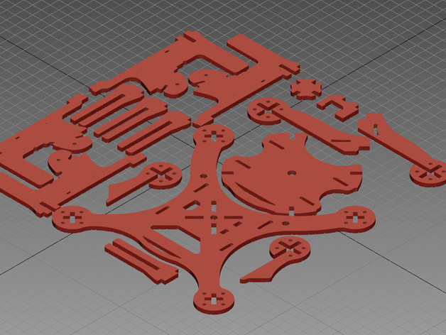
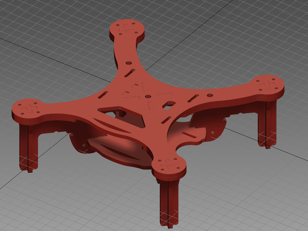
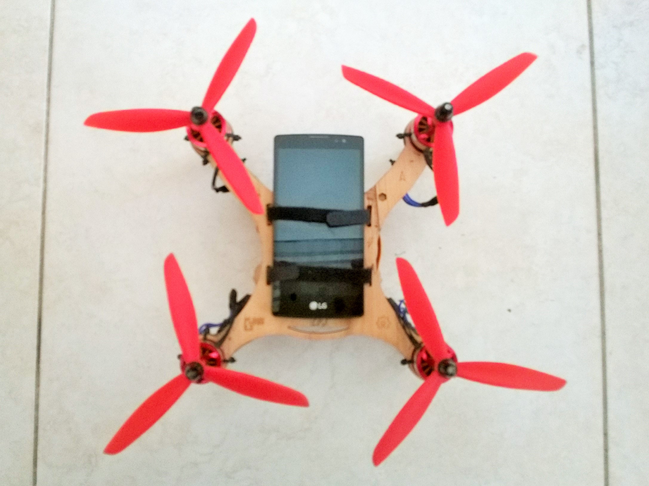
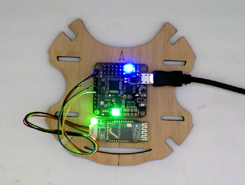
For these workshops we used an open source drone design called “Flone” (flying phone, flone.cc), which is quite easy to build, and was also quite well documented. The current documentation is in PDF in Spanish and is well designed and easy to read, but not easy to modify, and also in a wiki and an instructable in English (rather incomplete and not up to date).

One of our objective was therefore to contribute back by testing the documentation and finding ways in which it could be improved (just like we did with Richard’s microscope at GOSH). We identified some things to improve, not only technical but also the need to easily translate to different languages (we had people in the workshops who speak Spanish, English, Portuguese, French and Haitian Creole). Would anyone be up for helping translate into any of these languages?

Since documentation is the ‘source code’ of open hardware, we would like it to be easy to update, modify, but also accessible and easy to follow. Besides the text and images already available, we also shot some videos for each of the steps in the making process, which we would also like to include. Maybe we could suggest changing the documentation system to something more in line with the ‘best-practices’ that GOSH is trying to promote (as recommended in the Roadmap)… any ideas?

Another thing we would like to improve is the quality of the images that can be taken with the drone. The ‘flone’ is designed to carry a smartphone as a camera (although in theory you could try to fit any small camera). Our first tests were not great, because the vibration from the motors blurred the images a lot:

The structure of the flone is made of laser-cut plywood (it can be 3D printed too), and the phone is placed on top, held with straps and with some rubber in between. We found many examples online of vibration isolation/damping methods (e.g. this, this, and this), but we are wondering if maybe some of you have already tried them or have any recommendation, taking into account that the design should be easy to replicate with widely available materials. Ideas?

Another important aspect of the design that would need improvement is the range of the controller. The Flone is controlled using a smartphone app, which communicates with the flone via bluetooth. The range is therefore limited to about 10 meters (not too practical for aerial mapping). Before changing to a radio link, we thought we could try somehow extending the range of the bluetooth link. As usual, there are many examples online (e.g. this and this). Any recommendations about this?

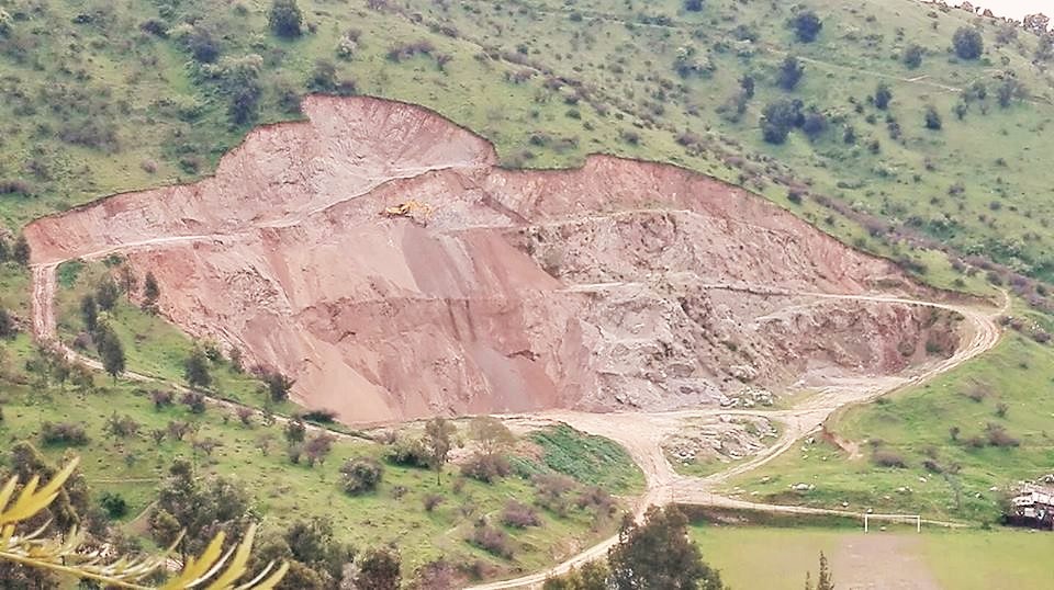
And regarding potential uses of the drone: one of the local issues identified in the workshops was that there is an illegal quarry in the local hill, right next to one of these neighbourhoods. A possibility would be for the people to use the drones to take aerial images to document the activity in this quarry, ideally using some sort of (open source) software to quantify the volume of material that is being taken out. I have some experience with closed-source software for aerial image processing (Agisoft Photoscan), but we wanted to try an open source alternative called Open Drone Map. Has anyone done this kind of measurements or tried this software?

Thank you all, gracias a todos!!! :slight_smile:

4 Likes

@gpereyrairujo and @paz. so cool! :slight_smile:

I know very little about Drones and aerial photos, so forgive me if the next lines are rubbish suggestions!

About the camera, I instantly thought about pixy http://charmedlabs.com/default/pixy-cmucam5/ since it seems this can be controlled by a wide range of microcontrollers/card sized computers… This way you probably won’t need a smartphone to control a smartphone, to take smartphone pictures :stuck_out_tongue:
Moreover, you could place colored tags on certain parts of the terrain you are trying to image, and have the system identify them… If you know the distance in between the tags and also the height difference between them, this could serve as a calibration system, or even a way to have the drone automatically follow a path?

Vibration, we face similar problems in electrophysiology systems and there normally we use really heavy objects as base/feet. Which is obviously not a solution for your application. I think this video https://www.youtube.com/watch?v=OnfYA5QLA84 could give a couple of hints on why your current systems do not work so well as the solutions they try are similar to the ones in the video. Another suggestion comes from a chat I had with the openAFM https://openafm.com/ people during GOSH 2016. They solved their vibration problems (after trying many different things) by using a semi inflated bike tire camera in between the microscope and the table.

Hope this makes sense…
do share more results once you have them!

2 Likes

Thanks for the feedback André!!!

The pixy camera looks interesting! I guess it could be possible to make it control the drone board!
And we will look into your suggestions about vibration - except the one about using a really heavy object! :laughing:

Abraço!
Gustavo

Hola Gustavo Pereyra, ¿donde podemos ubicarte?

Hola Roberto,
Yo vivo en Argentina, pero puedes contactar a @paz en Chile. Haciendo clic en el nombre de usuario nos puedes enviar un mensaje privado si quieres. También en twitter: pazbyc y gpereyrairujo
Un saludo!
Gustavo

Hola @gpereyrairujo @paz Great work!

Have you seen OSF (https://osf.io) ? We are using it for some projects and courses. I like the idea of having all in the same place…perhaps missing the social/chat/message layer.
I would like to hear what other people think about this initiative…
Best
F

2 Likes

Thanks Fernán!
I think OSF might be useful! Unlike github, which is code-oriented and can be intimidating for non-coders, OSF might be more accessible. I also like all the integrations, especially with google docs, which are very convenient for collaborative work (e.g. the gosh roadmap).
I will check your webinar!
Saludos!
Gustavo

Hey,
You can try Public Lab’s MapKnitter.org for stitching aerial images into maps and also annotating them and exporting different formats. Also, if you want to try a maybe more reliable and simple method as a backup to the DIY drone experiments use balloons and kites.

Good luck
Hagit

2 Likes

Hi Hagit! Thanks for the links :wink:
About the balloons and kites, we did try them, although briefly, gave only one Sunday to each. With the balloons we had great fun but it was a complete disaster. We didn’t have enough helium to put a 140grms phone up in the air, but also there was too much wind and eventually -and accidentally- the balloons were let loose (will upload a video about it in Instagram soon). But I guess my overall feeling with the balloons is that helium is way too expensive for us (and scarce as a resource too) to try again, at least in the short term. We had a bit or a better experience with a kite, and we did manage to attach a very small and light camera to it, but because we didn’t make a proper case for it, it moved too much and the video was too shaky. We do want to try again with kites, also having in mind we have lots of expertise with people knowing how to fly them around. I also got the public lab kit with both the balloon and kite. It was shipped last week, so super keen to see what we can do with it :slight_smile: We’ll let you know what we do.
salud!
paz

2 Likes

Hola todos,

We decided to start documenting our Flone project in OSF, following @ffederici’s suggestion. We will also apply to a mini grant from Mozilla Science Lab, we want to do a proper flone modification process, including collaborative workshops. What we said in OSF is pretty much the same we want to put in the Mozilla application… so, if you can please-please give us some feedback before the 17th (application deadline).

Also, does someone know about other mini grants or funds that we could apply to?

Grax!
Paz

Decidimos subir la documentación del proyecto de ‘enchulamiento’ o modificación de los flones en OSF (siguiendo la recomendación de @ffederici). Además postularemos a una mini grant de Mozilla Science Lab para poder hacer mejor las cosas. Lo que postularemos es en gran parte lo que pusimos en OSF así es que queríamos pedirles retroalimentación (antes del 17, deadline para postular) :wink:

Y además ¿alguna sabe de otros mini fondos o fondos que nos pudieran servir?

Gracias! y salud!
Paz

1 Like

Hey Paz (@paz) , aprovechando that we will be in Shenzhen, maybe we can arrange some drones to be taken from Shenzhen to Sombrero…watcha think?

1 Like

Genial! @keymer, when are you going to China? We will need to buy materials for modifying the flones, but we are not sure yet what those modifications are… We might have a better idea in January, when we, the crew, will meet to do new workshops (some in Spanish, some in Creole led by crew member Loulou)

When in January @paz? I would love to be on it. specially in creole! we should do a language workshop. I can teach C if they teach me Creole! Janneke and I will be in China all May. Let’s see what can we coordinate.

Sure! We’ll let you @keymer know when we have the dates :wink:

1 Like